Fort Cornwallis Moat – History and reinstatement today
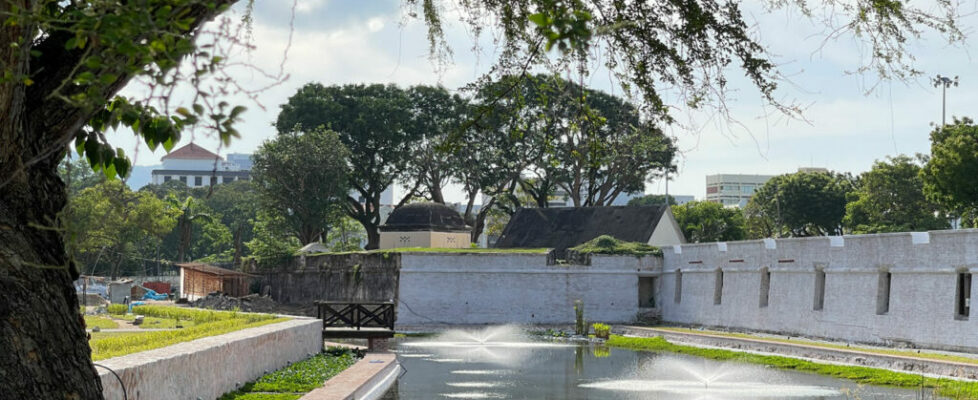
Opened for a sneak peak in July 2024, the first of the moat reinstatement phases in Fort Cornwallis is now ready. Here is a look at the South Moat and the Moat’s History.
Fort Cornwallis South Moat Today

And its surrounding landscapes:
You can learn more about the moat reinstatement project in our earlier post.
The History
In the case of Fort Cornwallis, a moat with a width of 9 to 20 metres surrounded the fort. Built in 1804, it was intended to respond to possible enemy threats during the Napoleonic Wars, a threat that in the end never materialised.
The moat’s shape and dimensions are clearly documented in the Kelly Maps of George Town, dating back to the late nineteenth century, as well as later photographic records. This information has been largely confirmed by the recent archaeological excavations, including the existence of an edge wall made of granite stones topped by a brick capping. It is not entirely clear how the moat was supplied with water due to the current uncertainties about the environmental conditions prevailing in earlier times.
Most probably, the moat basin filled up through a combination of rain water supplemented by subsoil ground water. The high water table levels prevailing in the ared would have risen or fallen in relation to the excursion of the tidal cycles. Water would have been brackish because of the moat’s proximity to the sed.
The moat was eventually filled in 1921/1922 as a result of a malaria 0utbreak that raised health concerns.
Shortly after its disappearance, periodic floods were reported in the Padang, indicating that the former moat “acted as an excellent drain for flood water” and noting that “the groundside inside the fort is below the level of the edge of the moat”. In other words, the moat acted as a reserve catchment area preventing flooding both in the areas surrounding the fortification and inside the low-lying interior court of the fort.
Over The Years
1791 – Fort Built
The plan may date from 1791 when Popham charted the southern channel. It may therefore show the nibong fort.

- Originally Francis Light’s cookrooms then granaries
- Probably ordinance stores
- Ditch
- Flagstaff
- Most likely to be barracks and cookrooms
- Possibly the barracks first built to house Light and his staff
1816 Moat Added
Interpretation of buildings in Fort Cornwallis in 1916 from original reports

- Guardroom
- Ordinance stores
- Conductor’s Quarters
- Gun Carriage
- Outworks
- Madras European Infantry Barrack
- Flagstaff
- Officer of the week and European cookroom
- Garrison Sergent Major
- Congee House and Guardroom
- 8 Storerooms civil, ordnance and Barrack master
- Ditch
- Bankshall
- Artillery Barracks
- Toilets
- Gun Powder
- Arsenal
1877 – Six decades later
Evolution of buildings six decades later.

- Barracks
- Magazine
- Ditch
- Military barracks
- Flagstaff
- Storerooms
Map-1891-93
Accurate plan of the fort by Government Surveyor F. W. Kelly

- Storerooms
- Barracks stores
- Lighthouse / Flagstaff
- Observatory
- Gymnasium
1908 Improvements
Blueprint plan for port improvements.

- Old gunpowder store and magazine
- Sikh Police Barracks
- Old magazine
- Old line of outworks still in existence
- Lighthouse / Flagstaff
- Buildings on ramparts
- Volunteer Force Drill Hall
- Buildings on bastion
- Old storerooms
1945 After the Japanese Occupation
Plan of the fort at the end of Japanese Occupation period.

- Old gunpowder store and magazine
- Light rail
- Western wall removed circa 1930
- Old magazine
- Outworks replaced with buildings
- Old lighthouse / flagstaff
- 1914 Lighthouse and Signal Station
- Moat filled in 1922
- Old storerooms
- Carpark (1930) but used for warehouses
- Sugar warehouse
1973 – Municipal
Municipal survey

- Old gunpowder store and magazine
- Ornate ponds
- Western wall still missing
- Old magazine
- New building erected
- Old lighthouse / flagstaff
- 1914 lighthouse
- Old Storerooms
- Carpark 1930
Current
Plan showing current day usage but before the moat reinstatement project.

- Old gunpowder store and magazine
- Western wall reconstructed 2001
- Old magazine
- Amphitheatre
- Stage
- Old and new lighthouses and meteorological station
- Old storerooms
- Carpark 1930
Here are photos of the moat in its glory days. These are photos taken from different angles. They make for an amazing insight into the way things were before more roads were added and the moat filled in. The first and second being images of post cards depicting the Queen Victoria’s memorial clock tower in the distance, with the moat in the foreground.


The Reinstatement Project


Looking Forward to the Future
While we can already see the completed Phase 6 of the project, the complete project is scheduled to be ready and open to public in July 2025, exactly one year from now. Here is a look at the project based on artist or architectural impressions.

- The restored moat at Fort Cornwallis will reopen to the public in July 2025.
- This project is part of ongoing efforts to rejuvenate Fort Cornwallis, enhancing its public appeal.
- The initiative is led by the George Town Conservation and Development Corporation (GTCDC) with support from the Chief Minister Incorporated (CMI) and Think City, and technical advice from the Aga Khan Trust for Culture.
- The project, including the reinstatement of the southern and western moats and a new food court, costs approximately RM20 million.


